
When you think of Switzerland, you think of the Alps. The mountains offer the perfect backdrop for hiking. You can enjoy the mountain scenery, serene lakes, waterfalls, glaciers, wildlife, and wildflowers while burning a few calories.
Looking at the terrain, it’s reasonable to assume that you need to be an expert hiker, but the variety of trails for hiking in Switzerland is endless. Yes, there are some challenging climbs, but there are also some hikes that are easy enough that they are suitable for children.
There are almost as many marked hiking trails as there are roads for motorized traffic in Switzerland. With all the trail options, how do you choose which one to hike? I have asked my fellow travel bloggers for some recommendations and compiled this list of the best hikes in Switzerland.
Note: This post contains affiliate links. Please see disclosure for more information.
Contents
Hiking in Switzerland
One of the nice things about hiking in Switzerland is that for some areas, you can cheat a bit by using mountain railways and cable cars instead of climbing up or down on foot. These scenic rides can be expensive but in many cases well worth it when it allows you to access sections you wouldn’t be able to otherwise. Depending on how much you plan to use these transport options, you may be able to save money using the Swiss Travel Pass.
To help navigate the hiking trails in Switzerland, you can use the free Switzerland Mobility App, which works offline. It is a comprehensive index of hikes listed by location, theme, and the required fitness level. The trails are all well-marked so finding your way shouldn’t be too difficult.
The Best Time to Hike in Switzerland
In general, July and August are the best months to go hiking in Switzerland. At lower altitudes, the season extends from May to October. There are some hikes that are around cities, towns, and villages that can be done all year, although it might be rainy and cold during early spring and late fall. In the winter, there are numerous trails for snowshoeing.
Keep in mind that it never gets all that hot at the higher altitudes, even in July and August. Snow is always a possibility and during the spring and fall, fog can make the trails invisible. It is important to check the weather forecast before you got out hiking. (If the weather doesn’t look good, maybe one of these Swiss museums can be your Plan B.)
What to Bring When You Go Hiking in Switzerland
Anytime you are hiking, it’s smart to be prepared. When you go hiking in Switzerland, I recommend that you bring along:
- Sun protection including sunglasses, sunscreen (this one is sweat-resistant), and possibly a hat. Remember the sun is stronger at higher altitudes.
- Proper footwear. This will vary depending on the intensity of the hike that you choose to do.
- Reuseable water bottle. It’s important to stay hydrated and be environmentally responsible. If you plan on doing one of the longer hikes, you might want to consider getting one of these hydration packs from CamelBak.
- Jacket. The weather can change quickly and gets cold at higher elevations. Check out the high-quality options at North Face here.
- Snacks. While there are several restaurants in the mountains in Switzerland, it is always a good idea to have a few snacks with you just in case. I like to bring a few granola bars or some trail mix.
12 of the Best Hikes in Switzerland
Now that we have covered the basic points of hiking in Switzerland, it’s time to learn about some of the most spectacular hikes where you can get some of the best views. Of course, this is a subjective list and by no means comprehensive.
The table below provides an overview of the top hikes in Switzerland. Most of the options here are day hikes, but there are also longer options. You would need a book to include all of the amazing hiking trails in Switzerland.
| Hike | Difficulty | Distance | Area | |
|---|---|---|---|---|
| Murren to Grutschalp Hike | Easy | 4.42 km | Jungfrau | |
| North Face | Easy | 6.9 km | Jungfrau | |
| Schilthorn Hike from Murren | Challenging | 12.9 km | Jungfrau | |
| Faulhornweg | Challenging | 16 km | Jungfrau | |
| Five Lakes Hike | Moderate | 9 km | Zermatt | |
| Matterhorn Glacier / Larchenweg Trails | Moderate | 10 -13 km | Zermatt | |
| Gelmersee | Easy | 5 km | Bernese Oberland | |
| Bachalpsee | Easy | 6 km | Bernese Oberland | |
| Olive Trail | Easy | 3.5 km | Lugano | |
| Maderanertal Valley | Moderate | 16 km | Lucerne | |
| Wispile to Lauenesee | Moderate | 14 km | Bern | |
| Montreux (La Rambertia Alpine Garden Trail) | Moderate | 11 km | Geneva | |
| Tour du Mont Blanc | Challenging | 170 km | Geneva |
The Best Hikes in Jungfrau
Murren to Grutschalp Hike
Recommended by Carolyn of Holidays to Switzerland

If you’re looking for an easy but scenic hike whilst you are in Switzerland’s Jungfrau Region, the Murren to Grutschalp trail is a perfect choice. It’s one of the best things to do in Interlaken and the surrounding area.
Starting beside the Murren train station, a well-made path meanders gently through alpine meadows with grazing animals and over bubbling streams to the hamlet of Winteregg and then on to Grutschalp. Following the railway line for much of the way, the 4.42-kilometre path is mostly flat and is suitable for all ages.
The trail can be completed in just over an hour but you’ll probably take longer as you’ll be stopping so often to take in the stunning panoramic views. Have your camera ready to capture the beauty of the snow-capped Eiger, Jungfrau, and Monch.
There are mountain restaurants at both Winteregg and Grutschalp should you need some refreshments and during the summer months, Alpkaserie Staubbach at Winteregg sells the most delicious cheese and yogurt straight from the farm gate. You’ll find it right by the Winteregg station.
You can reach Murren either by cable car from Stechelberg (near Lauterbrunnen) or by cable car and train from Lauterbrunnen. Lauterbrunnen is easily accessed by train or car from Interlaken.
For a perfect day out, combine your hike with a visit Mt. Schilthorn.
North Face Trail
Recommended by Mikaela from Voyageur Tripper

The North Face hike sounds much more intimidating than it is. This easy, moderately-trafficked loop takes hikers from the town of Murren on a spectacular walk in the mountains.
Since Murren is already located on the mountainside (and requires a gondola to get to), travelers can hike at a higher elevation without needing to gain all that elevation themselves. The trail can also be accessed from the nearby town of Gimmelwald, however, this requires several steep switchbacks at the beginning.
In addition to mountain views, The North Face will treat hikers to quaint mountain homes, an alpine creek, wildflowers, and access to several other trails in the area. Leaving the trail temporarily and following the sign to Spurtz will take hikers to a waterfall that can be walked underneath.
Although not required, hikers should wear sturdy hiking boots, dress in layers, and bring a water bottle – especially those not accustomed to hiking at altitude. It’s best to allow 2 – 2 1/2 hours to finish this 6.9 km hike.
Schilthorn Hike from Murren
Recommended by Jackson from Journey Era

The Schilthorn hike from Murren is a challenging trek with more than 1600m of incline throughout the trail, all the way to the Piz Gloria summit where James Bond ‘007’ was filmed.
The trail begins in the picturesque, mountain town of Murren with the first part of the hike to Rotstockhutte being relatively easy. Most families will be able to hike their way to Rotstockhutte with only a 300-400m increase in elevation.
However, after Rotstockhutte the Schilthorn trail to Piz Gloria summit is very steep. In this section of the hike, you will cover more than 1000-meters of an incline in just a few kilometers, which means it is just straight up the mountain. Here you clamber over rocks and are constantly heading uphill.
The total hike distance is 12.9km from Murren to the summit. If you want to hike down you will need to almost double that distance but most hikers catch the scenic Schilthornbahn down to Murren, which was a nice way to return after a long day on the legs to complete the loop.
Faulhornweg
Recommended by Wendy Werneth of The Nomadic Vegan

This hiking trail runs from Schynige Platte to First and is known as the Faulhornweg, named after the Faulhorn peak that you’ll be climbing along the way. It’s considered to be one of the best hikes in the Jungfrau region, and while fairly challenging, it’s definitely worth it. The trail runs for 16 kilometers, and it takes about six hours to cover the whole thing.
The closest major town is Interlaken, from where you can take a regular train to Wilderswil and then a very scenic ride on a rack-and-pinion railway to the trailhead at Schynige Platte. Two main highlights of the hike are the views of Lake Brienz and the Jungfrau massif from the Faulhorn and the views of the Wetterhorn from First.
Once you reach First, you have the option of either walking down to Grindelwald, which will take another hour or two, or taking the gondola down for 30 CHF. In Grindelwald, you can refuel at Eiger +, a café that serves healthy, fresh dishes with some options for vegetarian and vegan visitors to Switzerland.
Best Hikes in Zermatt
Zermatt Five Lakes Hike
Recommended by Smita from My Faulty Compass

One of the most popular trails & one of the best things to do in the Zermatt area is the Five Lakes hike covering the beautiful lakes of Stellisee, Grindjisee, Grünsee, Moosjisee, and Leisee. The spectacular Matterhorn stays with you through the entire hike and (weather permitting!) you can get some fantastic reflection shots of the mountain in the lakes.
This hike covers a distance of ~9 km and takes ~3 hours to complete, with an ascent of ~250 m and a descent of ~520 m. To start the hike, take the funicular from Zermatt to Sunnegga and then a cable car to Blauherd.
The first lake, Stellisee is an easy walk away. Matterhorn’s reflection in this lake is absolutely breathtaking! The second lake Grindjisee is a downhill walk from Stellisee. Surrounded by trees, this mountain lake is spectacular. A downhill hike from here brings you to the third lake Grünsee and its sandy shores. A slightly challenging route through some steep switchbacks brings to you the next lake Moosijsee. The dramatic color of this lake will make you fall in love with it! The last lake Leisee requires an uphill hike but the rewarding views of the Matterhorn make it worth the effort!
Matterhorn Glacier Trail and Larchenweg in Zermatt
Recommended by Karen from Big Adventures for Little Feet

Hiking in Switzerland tops my list of favorite things to do anywhere in the world and Zermatt is one the best hiking destinations ever. Many people have seen images of the Matterhorn mountain located adjacent to the beautiful town of Zermatt. There are loads of hiking trails in this area but one particularly fabulous option is to combine the Matterhorn Glacier Trail and the Larchenweg Trail which will bring you either up or down the mountain directly underneath the Matterhorn.
If you choose to climb the trail upwards it will be a challenging hike. The easier option is to take the gondola to begin your climb from the top and work your way back to Zermatt Village via the combination of the Matterhorn Glacier Trail and Larchenweg as we did. I recommend taking the gondola to the very top to experience the Matterhorn Glacier Paradise before descending back on the gondola to the start of the Matterhorn Glacier trailhead from Trockener Steg station.
This trail is classified as medium difficulty however for seasoned hikers it will be a pretty comfortable but long hike easily broken up with some pit stops and photo opportunities. As most of the trail is descending it can get tough on the knees so good sturdy shoes are a must. It’s also smart to dress in layers to accommodate the change in altitude throughout the day.
The scenery along this hike will leave you breathless. The Matterhorn Glacier trail is the top 6.5 km and winds itself down the northern side of the Matterhorn. You get postcard-perfect scenes the whole way including glacier views and perfect shots of the Matterhorn.
As you move lower and pass through Schwartzee you move onto the Larchenweg Trail consisting of many switchbacks to move you deeper into the valley below the Matterhorn. The vegetation increases and the Swiss greenery becomes the feature once more as you complete this 4.4 km stint to bring you back to the village of Furi. If you want to continue walking all the way back to Zermatt it is a further 2-3 km depending on where you are staying.
This combination of trails all the way back to Zermatt will take at least 5-6 hours but if you take into account a visit to the top of Matterhorn Paradise you are best to allocate a full day to appreciate this activity.
Best Hikes in Bernese Oberland
Gelmersee Hike
Recommended by Kat from Wandering Bird

If you’re looking for a spectacular hike in Switzerland, you have to go to Gelmersee. Gelmersee Lake is up in the Swiss Alps and is one of the prettiest lakes I have ever seen. The color of the water is just breathtaking (it really is that green), and the views of the mountains around it are equally mesmerizing. It’s the perfect destination for a day hiking.
Depending on your fitness (and level of crazy!) there are two ways to reach the lake – by hiking up a (big!) mountain. Or by taking the Gelmerbahn Funicular. The Gelmerbahn Funicular is one of the steepest mountain railways in the world. The gradient is 106% and it goes STRAIGHT up the mountain. It was a mixture of terrifying and exhilarating and was one of the highlights of our trip to Switzerland.
If you’ve taken the funicular up, you can then spend the rest of the day hiking back down or around. There are several routes and you can buy a guide in the office by the car park, although they are fairly well marked. The hike around the lake is about 5 km and should take about 2-3 hours to complete. There are no facilities or cafe up at Gelmersee, so remember to take food and water with you.
Bachalpsee
Recommended by Ivan from Mind the Travel

If you are headed to the Interlaken or Grindelwald area, then it’s definitely worth checking out one of the most stunning alpine lakes in Switzerland. Located in the Bernese Oberland region, Bachalpsee is surrounded by wildflowers and adorned with a scenic backdrop of stunning mountains, and lush meadow.
An enchanting view of the surrounding mountains is what makes the hike worthwhile. You can also see a reflection of phenomenally beautiful mountain ranges over the lake. It is a dazzling sight, and it will make your eyes wet for sure. The 6km-long trail starts from the Grindelwald First cable car station, while the entire hike takes approximately two hours.
Once you get there, start the hike just by following the signs to Bachalpsee. There are some ascents and descents during the first 3 km of the route but after that, the trail is quite gentle.
The views of the Jungfrau region are incredible and you will want to stop every few minutes to take photos. Do take a hat with you since there’s no shade along the way and lake surface reflects the sun’s rays and can cause sunburns.
Once you reach the lake, you’ll find plenty of spots for a picnic and even swim if you’re daring enough to take the plunge into some chilly water. Do note that there is nowhere to eat at the top so bring your own water and food.
Once you’ve soaked in the scenery at the lake, head back the same way. If you are feeling more adventurous consider walking down towards Bort. This is one of the middle stations on the cable car route with a pretty good restaurant. If you don’t feel like continuing with the rest part of the trail, you can take the cable car down from Bort to Grindelwald.
Best Hikes Near Lake Lugano
Olive Trail in Lugano
Recommended by Susan from Luxury Columnist
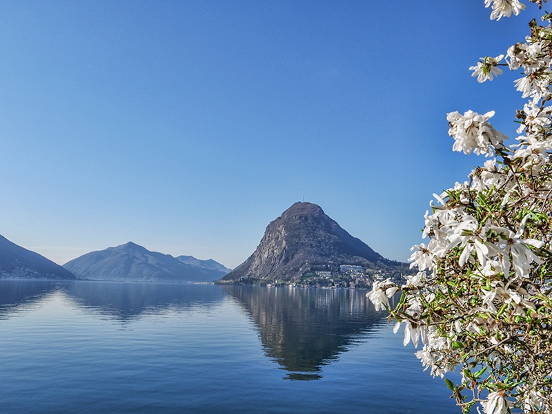
The Olive Tree Trail is one of the best things to do in Lugano. This is an easy hike for people of all abilities, taking you through olive groves and alongside Lake Lugano. There are no cars so it’s extremely peaceful.
The path has a few steps, and it’s good to wear hiking shoes but not essential. The hike starts at Castagnola near the old community center, on the banks of Lake Lugano. It’s signposted with an olive tree symbol. Castagnola is easy to reach from the center of Lugano on foot or by car.
Along the way, there are 18 multi-lingual information boards explaining the history and cultivation of olives. The hike is 3.5 kilometers long and takes around 1 hour to complete.
You can eat or swim at the lakeside lido café, and there are also benches along the trail. Look out for the Olivo di Carlin olive tree, close to Grandria. This centennial olive tree is 10 meters high.
This walk finishes at the charming lakeside village of Gandria. If you don’t want to walk back, there are bus and boat ferry stops at the end of the trail.
Best Hikes Near Lucerne
Maderanertal Valley
Recommended by Annabel from Smudged Postcard

Hiking in the Maderanertal Valley in the canton of Uri is a rewarding Swiss hike for families with young children or for individuals looking for a relaxing hike with incredible views. Due to the gentle nature of the pathways in this 16 km hike, children as young as five can comfortably complete the walk as there are two overnight stopping points.
The hike is reached via the Bristen cable car which takes visitors up to the hamlet of Golzern. The lake at Golzern is a wonderful spot for a swim and there are a couple of guesthouses serving lunch and offering overnight accommodation.
From the lake, there is a pathway descending through forests to the Chärstelenbach river. The forests are perfect for foraging for strawberries and blueberries in the summertime. There is a mountain dairy to stop at for refreshments before a gentle ascending track to Hotel Maderanertal for an overnight stay. There are fabulous views of Mount Bristen from the hotel.
From the Maderanertal Hotel, the track winds down the valley along the river back to the base of the Bristen cable car. There is a final guesthouse along the river at which to refuel.
Best Hikes Near Bern
Wispile to Lauenesee
Recommended by Simon from Wild About Travel

Gstaad, one of the favorite mountain resorts in Switzerland, and the Saanenland are a fantastic area for hiking lovers. There are plenty of trails. Easy hikes suitable for families with small kids, moderate itineraries, and more challenging routes.
One of the most beautiful hikes is the trail from Wispile to Lauenensee, by a tiny, charming lake. The walk takes about 3 hours and presents no particular difficulties. However, keep in mind that you’ll climb down from 1,939 m to 1,380 m, so better use hiking poles to minimize the impact of the descent on your knees.
Getting there by public transportation is easy. Gstaad is along the way of the Golden Pass scenic train line, and from the station, it’s a 15-20 minutes walk to reach the Wispile cable car station. After a short ride, you’ll reach the Wispile upper station and the lovely mountain hut. Up there, you have an incredible 360° view of the surrounding mountains. If you’re traveling with kids, they’ll love the wooden children’s playground, and looking at the cute goats grazing around.
The first stretch of the hike is easy and follows the ridge. Now and then, you’ll spot a bench that makes a perfect spot for a scenic picnic. From the end of the hill, the walk is downhill almost all the time. Part of the trail is in the forest, offering a much-appreciated shade in summer. As you approach the valley, you’ll start seeing Lake Lauenen. Bring your swimsuit to have a refreshing swim, and relax on the terrace of the charming restaurant. In summer, there’s a bus service to get back to Gstaad from Lauenensee. Otherwise, you’ll have to walk to Lauenen (about 1 hour) and catch the bus from there.
Best Hikes Near Geneva
Montreux
Recommended by Mark from Vogatech
If you’re a fan of hiking and an outdoor enthusiast, then the hills around Montreux is where you need to be. Perched above the world-famous Lake Geneva, the surrounding hills on the French side offer 60 hiking trails to choose from.
La Rambertia Alpine Garden is one of the most popular trails that heads from Montreux to the summit of the Rochers de Naye. The trail is little under 11 kilometers long and it takes 8 hours to complete because of the difficult terrain. However, the elevation is only 4 meters, while you’ll descend more than a kilometer and a half to the other side of the mountains.
A more difficult trail is Via L’Etivaz AOP. The distance from Etivaz village to the peak of Les Avants is nearly 59 kilometers. No wonder then it takes 18 hours to complete the trail that takes you up and down more than 2 kilometers in elevation. Most of the time, you’ll be walking through a park and across valleys with historical villages along the way.
Tour du Mont Blanc
Recommended by Mags from Tour du Mont Blanc Hike

The Tour du Mont Blanc is a 170 km hut to hut trekking trail through France, Italy, and Switzerland circumnavigating Western Europe’s highest mountain, Mont Blanc. Classed as one of the world’s classic multi day treks, hikers can complete the trail in 10-11 days staying each night in comfort at high altitude refuges. The Tour du Mont Blanc leads hikers though some seriously staggering landscapes over challenging terrain – this trail has more accumulated elevation than climbing Mount Everest!
The soaring peaks of ice and rock making up the Mont Blanc Massif mountain range are spell binding. Countless colossal glaciers spill down from vast walls of impenetrable rock, snow and ice creating dramatic backdrops whilst crossing unmanned borders over remote high mountain passes the trail takes hikers along delightful balcony forest trails and down into charming alpine pastures. Rocky boulder fields on variant routes transport you into lunar landscapes whilst fixed iron ladders on a couple of sections will get your heart racing.
The Tour du Mont Blanc is a truly wonderous way to experience Europe allowing you to delve into the culture, landscapes, and cuisine of three different countries. The trek offers the experience of high altitude trekking but with the home comfort of the refuges, never further than 5 km apart. The Tour du Mont Blanc is the most famous European trek and should be on every serious hiker’s bucket list.
More Hikes in Europe
If you enjoy hiking, you might also be interested in some of the posts we have written about other hikes in Europe:
- The Best Hikes in Portugal
- Old Man of Storr Hike in Isle of Skye, Scotland
- Monte Urgull in San Sebastian, Spain
The Best Places to Hike in Switzerland
Switzerland is a paradise for hikers and nature-lovers, so make sure you allow some time to spend outdoors when planning your itinerary. There are many options for all ability levels. You don’t have to be in top physical shape to hike in Switzerland, some trails are even suitable for kids. This list of the most beautiful places to go hiking is just a starting point.
Have you done any of these hikes?
-Anisa
Pin for Later

Expert Tips for Hiking in Switzerland
- Download the Switzerland Mobility App to help you plan your hiking adventure.
- Check the weather before hiking in the Swiss Alps and be prepared for the elements.
- Consider getting the Swiss Travel Pass to save money on transport.
- Grab my free travel checklist to help with the planning of your trip.
Disclosure: This post contains affiliate links. This means we will receive a small commission for some purchases made using links in our blog with no additional cost to you. Please be assured we would not promote any product unless we believe that our readers will also benefit. The commission does not influence the editorial content of this site.
Two Traveling Texans is a participant in the Amazon Services LLC Associates Program, an affiliate advertising program designed to provide a means for sites to earn advertising fees by advertising and linking to amazon.com, amazon.co.uk, amazon.ca. Amazon and the Amazon logo are trademarks of Amazon.com, Inc. or its affiliates.
Last Updated on March 31, 2022